Whitman County Road

RAP Regions

Grants Contact Information

Steve Johnson

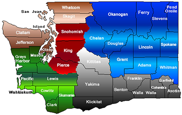
Funding from the RATA (Rural Arterial Trust Account) is distributed to five regions in Washington State based on rural land area and the total number of miles of eligible roads in each region. Because of population growth and new roads that are added or removed from the transportation network from time to time, the regional distribution percentages are adjusted every biennium.

View regional descriptions by clicking your mouse on a region of the map. See text version.

RAP Regions in the State of Washington

Washington County map depicting RAP Regions SE RAP Region NW RAP Region NE RAP Region SW RAP Region PS Region


The five regions in Washington State include:

  • Northwest Region
  • Northeast Region
  • Southwest Region
  • Southeast Region
  • Puget Sound Region

Northwest Region

Bordered by the Pacific Ocean, the Puget Sound, and containing portions of both the Olympic and Cascade Mountain Ranges, the NW region has a diverse resource base. This includes logging, farming, fishing, tourism and recreation. Two of the seven counties are comprised of islands which experience considerable recreational traffic. Gaining a little over 11% of the funding available statewide, these counties use RATA funds judiciously on their neediest rural roads.

Southeast Region

The many productive vineyards and fruit orchards in the SE Region are made possible by irrigation from the Columbia, Snake and other local rivers. The counties in this region pursue the important task of upgrading their roads so they can serve haul needs year-round. These roads also haul logs, livestock, grain and vegetables to ports on the Columbia River and onto the state highway system.

Southwest Region

The SW Region is bordered by the Columbia River to the south and the Pacific Ocean to the west. Combined with mountains to the north and east, annual rainfall approaches 200 inches in some locations. Transportation improvement projects in this region therefore face significant drainage, wetlands and flooding issues that raise reconstruction costs considerably. While the emphasis of heavy industrial and commercial freight haul on rural arterial roads in the SW region has continued, the growing population over recent years has placed more pressure to improve commuter and recreational traffic service.

Puget Sound Region

The Puget Sound Region has a varying landscape with the Cascade Mountains to the east, the major shipping lanes of the sound to the west, and cities and farming communities of the valleys in between. These characteristics have created a dense rural road system that serves many uses. Even though the Puget Sound region is considered the metropolitan center of Washington State, the three Puget Sound counties use RATA funds to rebuild rural roads, bridges, and intersections that would otherwise quickly fail because of their proximity to the ever expanding fringes of urban growth.

Northeast Region

The NE Region is comprised of 11 counties that make up the largest portion of the county rural arterial system in Washington State. One area is the lower, semi-arid grain belt that is dedicated mainly to wheat farming. Remnants of the abandoned rail system that once transported grain and other produce are still in place throughout the region. RAP funds are also used to improve access to orchards in the west and timber in the north.